GeoDataINRAE
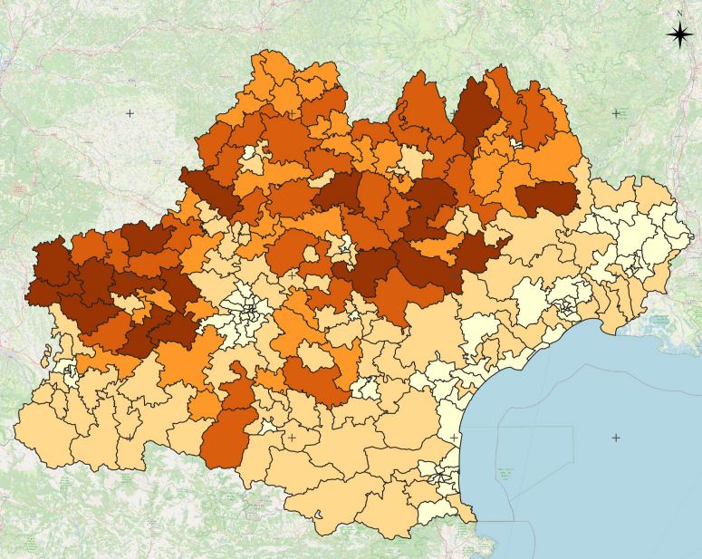
Projet Artisols - Coefficient de dispersion par canton - Occitanie - 2015 à 2019
Le coefficient de dispersion représente le rapport entre la surface des espaces artificialisés (taches urbaines) morcelés, définis ici pour une emprise inférieure à 3 hectares, et celle des espaces artificialisés denses supérieurs ou égales à 3 hectares.Cet indicateur a été calculé par canton et pour les années 2015 à 2019.
Simple
- Date (Revision)
- 2022-05-17T19:10:21
- Edition
-
1.0
- Edition date
- 2015-01-01
- Citation identifier
- f69abf04-45a2-4bdb-b79d-50a6a001646c
- Cited responsible party
-
Organisation name Individual name Electronic mail address Role INRAE - UMR TETIS
Eric Barbe
Principal investigator
- Purpose
-
Cet indicateur permet d’évaluer l’influence du phénomène de mitage en analysant la tendance au morcellement ou à la compacité d’un territoire. Plus il est élevé, plus la tendance du territoire est au mitage et à la dispersion des espaces artificialisés. Il peut être également intéressant de suivre cette évolution dans le temps.
- Status
- Completed
- Point of contact
-
Organisation name Individual name Electronic mail address Role INRAE - UMR TETIS
Eric Barbe
Principal investigator
- Maintenance and update frequency
- Not planned
-
General
-
-
Urban sprawl
-
- Use limitation
-
This work is licensed under a Creative Commons Attribution 4.0 License (CC BY 4.0, https://creativecommons.org/licenses/by/4.0).
- Access constraints
- License
- Use constraints
- License
- Classification
- Unclassified
- User note
-
unclassified
- Classification system
-
no classification in particular
- Handling description
-
description
- Spatial representation type
- Vector
- Language
- Français
- Character set
- UTF8
- Topic category
-
- Imagery base maps earth cover
))
- Begin date
- 2019-01-01T00:00:00Z
- End date
- 2019-12-31T00:00:00Z
- Supplemental Information
-
some additional information
- Reference system identifier
- EPSG / 2154
- Distribution format
-
Name Version GPKG
1.0
Digital transfer options
- OnLine resource
-
Protocol Linkage Name file for download
https://doi.org/10.15454/T6OBBY DOI Coefficient de dispersion
OGC:WMS
https://idg-tetis.teledetection.fr/geoserver/Artisols/wms cantons_coef_Disp
- Hierarchy level
- Dataset
Conformance result
- Title
-
Data Quality check
- Alternate title
-
This is is some data quality check report
- Date (Publication)
- 2022-05-17T19:10:21
- Explanation
-
some explanation about the conformance
- Pass
- Yes
Conformance result
- Title
-
Commission Regulation (EU) No 1089/2010 of 23 November 2010 implementing Directive 2007/2/EC of the European Parliament and of the Council as regards interoperability of spatial data sets and services
- Date (Publication)
- 2010-12-08T12:00:00
- Explanation
-
See the referenced specification
- Pass
- Yes
Conformance result
- Title
-
COMMISSION REGULATION (EC) No 1205/2008 of 3 December 2008 implementing Directive 2007/2/EC of the European Parliament and of the Council as regards metadata
- Date (Publication)
- 2008-12-04T12:00:00
- Explanation
-
See the referenced specification
- Pass
- Yes
- Statement
-
Ce coefficient est calculé en faisant le rapport entre la surface des espaces artificialisés (taches urbaines) morcelés, définis ici pour une emprise inférieure à 3 hectares, et celle des espaces artificialisés denses supérieurs ou égales à 3 hectares.
Metadata
- File identifier
- f69abf04-45a2-4bdb-b79d-50a6a001646c XML
- Metadata language
- English
- Character set
- UTF8
- Parent identifier
-
ArtiSols Project
0f2bb3f7-7094-407c-9082-184b667aa577
- Hierarchy level
- Dataset
- Date stamp
- 2022-05-17T19:21:43
- Metadata standard name
-
ISO 19115:2003/19139
- Metadata standard version
-
1.0
- Metadata author
-
Organisation name Individual name Electronic mail address Role INRAE - UMR TETIS
Kenji Ose
Point of contact INRAE - UMR TETIS
Eric Barbe
Principal investigator INRAE - UMR TETIS
Alexia Cornic
Publisher INRAE - UMR TETIS
Alexia Cornic
coAuthor INRAE - UMR TETIS
Kenji Ose
coAuthor
)))