GeoDataINRAE
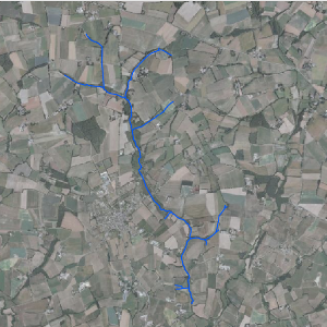
Réseau hydrographique : site de Naizin (Ore AgrHyS)
Représentation du réseau hydrographique sur la zone d'étude INRA de Naizin.
Simple
- Date (Creation)
- 2011-08-01T00:00:00
- Edition
-
2011
- Citation identifier
- fr-18007003900276-umrsas-ore-nzn_rh
- Presentation form
- Digital map
- Purpose
-
AgrHyS est un des 25 Observatoires de Recherche en Environnement (ORE) labellisés par le Ministère de la Recherche en 2002. Il a pour objectif d’étudier les temps de réponse des flux hydrogéochimiques à l'évolution des agro-hydrosystèmes.
- Status
- Completed
- Point of contact
-
Organisation name Individual name Electronic mail address Role UMR 1069 SAS INRA - Agrocampus Ouest
Contact ORE AgrHyS
Point of contact
- Maintenance and update frequency
- As needed
-
external.place.ore
-
-
Naizin
-
-
external.place.thematiques
-
-
Hydrologie
-
-
external.place.departements
-
-
Morbihan
-
- Keywords
-
-
données ouvertes
-
-
INSPIRE themes
-
-
Hydrographie
-
Installations de suivi environnemental
-
- Use limitation
-
Usage libre sous réserve des mentions obligatoires sur tout document de diffusion : "Source : UMR 1069 SAS INRA - Agrocampus Ouest"
- Use limitation
-
Licence ouverte : http://wiki.data.gouv.fr/wiki/Licence_Ouverte_/_Open_Li
cence
- Access constraints
- Other restrictions
- Use constraints
- License
- Other constraints
-
Pas de restriction d’accès public
- Spatial representation type
- Vector
- Denominator
- 5000
- Language
-
fre
- Character set
- UTF8
- Topic category
-
- Farming
- Begin date
- 2011-08-02T11:19:00
- End date
- 2016-08-02T11:19:00
))
- Supplemental Information
-
Champs de la table attributaire
ID: numéro identifiant
Longueur: longueur du segment en mètre
CodeHydro: code hydrologique du cours d'eau (BD Carthage)
ZoneEtude: cours d'eau situé sur la zone d'étude
Régulier: cours d'eau alimenté plus de huit mois dans l'année
(NA: non renseigné)
- Reference system identifier
- WGS 1984
- Reference system identifier
- EPSG / RGF93 / Lambert-93 (EPSG:2154) / 7.4
- Distribution format
-
Name Version ESRI shapefile
ESRI shapefile
Digital transfer options
- OnLine resource
-
Protocol Linkage Name WWW:LINK-1.0-http--link
http://www6.inra.fr/ore_agrhys Site Web de l'observatoire de recherche en environnement AgrHyS
WWW:LINK-1.0-http--link
https://geosas.fr/web/ Portail de l information geographique de l UMRSAS
OGC:WMS
https://geosas.fr/geoserver/ore/wms?service=WMS&request=GetCapabilities nzn_rh
WWW:DOWNLOAD-1.0-http--download
https://geosas.fr/geoserver/wfs?service=WFS&version=2.0.0&request=GetFeature&typeName=ore:nzn_rh&outputFormat=SHAPE-ZIP
- Hierarchy level
- Dataset
- Statement
-
Couche vecteur du réseau (ABIVEN. S., 2000)
Correction des tracés et création de nouveaux champs dans la table attributaire (LE GUILLOU. F., 2011)
Metadata
- File identifier
- f5ceee60-c8db-4a96-a4f4-a7c922b43c8f XML
- Metadata language
-
fre
- Character set
- UTF8
- Parent identifier
-
e97d3159-e1ae-4939-8af0-acd588ba75b0
e97d3159-e1ae-4939-8af0-acd588ba75b0
- Hierarchy level
- Dataset
- Date stamp
- 2020-12-15T15:20:21
- Metadata standard name
-
ISO 19115:2003/19139
- Metadata standard version
-
1.0
- Metadata author
-
Organisation name Individual name Electronic mail address Role UMR 1069 SAS INRA - Agrocampus Ouest
Service GéoSAS
Point of contact
)))