GeoDataINRAE
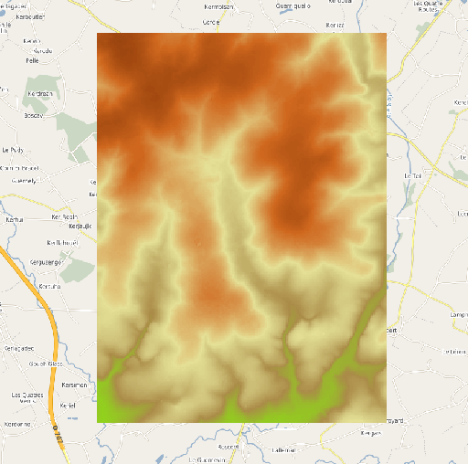
MNT à 25 mètres de résolution (BD Alti) de Naizin
Modèle Numérique de Terrain (MNT) à 25 mètres de résolution extrait de la BD ALTI Version 2.0 de l'IGN à 25 mètres de résolution. L'emprise géographique du MNT correspond au site de l'Observatoire de Recherche en Environnement (ORE) AgrHyS de Naizin dans le Morbihan.
Simple
- Date (Publication)
- 2020-11-19
- Edition
-
1.0
- Citation identifier
- fr-130005127-umrsas-ore-nzn_mnt_ign_25m
- Purpose
-
Proposer aux scientifiques un MNT "prêt à l'emploi" pour les travaux de modélisation
- Status
- Completed
- Point of contact
-
Organisation name Individual name Electronic mail address Role UMR 1069 SAS INRA - Agrocampus Ouest
Service GéoSAS
Point of contact
- Maintenance and update frequency
- As needed
- Theme
-
-
ORE AgrHys
-
MNT
-
BD Alti
-
Données ouvertes
-
-
external.place.localisation
-
-
France
-
-
UMR SAS Themes
-
-
Altimétrie
-
-
INSPIRE themes
-
-
Altitude
-
- Use limitation
-
Usage libre sous réserve des mentions obligatoires sur tout document de diffusion : "Source : • copyright « © IGN – 2021 »"
- Use limitation
-
Licence ouverte V2.0 : https://www.etalab.gouv.fr/wp-content/uploads/2017/04/ETALAB-Licence-Ouverte-v2.0.pdf
- Access constraints
- Other restrictions
- Use constraints
- License
- Spatial representation type
- Grid
- Distance
- 10 m
- Language
-
fre
- Topic category
-
- Elevation
- Description
-
France
))
- Reference system identifier
- EPSG / RGF93 / Lambert-93 (EPSG:2154) / 7.5.0.1
- Distribution format
-
Name Version GeoTIFF
1.0
Distributor
- Distributor contact
-
Organisation name Individual name Electronic mail address Role UMR 1069 SAS INRA - Agrocampus Ouest
Service GéoSAS
Distributor
- Distributor format
-
Name Version raster
1.0
Digital transfer options
- OnLine resource
-
Protocol Linkage Name OGC:WMS
https://geosas.fr/geoserver/ore/ows?service=WMS&request=GetCapabilities nzn_mnt_ign_25m
WWW:DOWNLOAD-1.0-http--download
https://geosas.fr/geoserver/ows?service=WCS&version=2.0.1&request=GetCoverage&coverageId=ore__nzn_mnt_ign_25m&format=geotiff
- Hierarchy level
- Dataset
Conformance result
- Date (Creation)
- 2014-02-01
- Explanation
-
Non Evalué
- Pass
- Yes
- Statement
-
Ce modèle numérique de terrain est extrait de la BD Alti Version 2.0 de l'IGN à 25 mètres de résolution
Metadata
- File identifier
- c199a6d9-6b85-4aee-9793-dde0b384b757 XML
- Metadata language
-
fre
- Character set
- UTF8
- Hierarchy level
- Dataset
- Date stamp
- 2022-01-13T10:29:32
- Metadata standard name
-
ISO 19115
- Metadata standard version
-
1.0
- Metadata author
-
Organisation name Individual name Electronic mail address Role UMR 1069 SAS INRA - Agrocampus Ouest
Service GéoSAS
Point of contact
)))