GeoDataINRAE
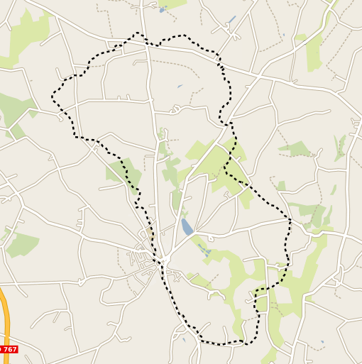
Délimitation du bassin versant de Naizin (ORE AgrHyS) - MNT Mégalis 20 m.
Représentation du contour du bassin versant du site de Naizin dans le Morbihan dans le cadre de l'Observatoire de Recherche en Environnement (ORE) AgrHyS de l'INRAE. Cette couche spatiale a été calculée à partir du Modèle Numérique de Terrain Mégalis à 20 m. de résolution. Ce contour correspond au bassin versant de 12km2 du cours d'eau du Coetdan, le sous bassin sur lequel les observations hydrochimiques sont concentrées depuis 1993 se situe dans les 5km2 amont.
Simple
- Date (Creation)
- 2021-12-22T09:00:00
- Edition
-
2021
- Citation identifier
- fr-18007003900276-umrsas-ore-naizin_bv_mnt20geob
- Purpose
-
AgrHyS est un observatoires de Recherche en Environnement (ORE) labellisé par le Ministère de la Recherche en 2002. Il a pour objectif d’étudier les temps de réponse des flux hydrogéochimiques à l'évolution des agro-hydrosystèmes, en particulier ceux dominés par une activité de polyculture élevage en région tempérée humide.
- Status
- Completed
- Point of contact
-
Organisation name Individual name Electronic mail address Role UMR 1069 SAS INRA - Agrocampus Ouest
Contact ORE AgrHyS
Point of contact
- Maintenance and update frequency
- As needed
-
external.place.thematiques
-
-
Hydrologie
-
-
external.place.ore
-
-
Naizin
-
-
external.place.departements
-
-
Morbihan
-
- Keywords
-
-
données ouvertes
-
-
INSPIRE themes
-
-
Hydrographie
-
Installations de suivi environnemental
-
- Use limitation
-
Usage libre sous réserve des mentions obligatoires sur tout document de diffusion : "Source : UMR 1069 SAS INRA - Agrocampus Ouest"
- Use limitation
-
Licence ouverte : http://wiki.data.gouv.fr/wiki/Licence_Ouverte_/_Open_Li
cence
- Access constraints
- Other restrictions
- Use constraints
- License
- Other constraints
-
Pas de restriction d’accès public
- Spatial representation type
- Vector
- Denominator
- 25000
- Language
-
fre
- Character set
- UTF8
- Topic category
-
- Farming
))
- Reference system identifier
- EPSG:2154
- Reference system identifier
- EPSG / RGF93 / Lambert-93 (EPSG:2154) / 7.4
- Distribution format
-
Name Version ESRI shapefile
ESRI shapefile
- Distributor contact
-
Organisation name Individual name Electronic mail address Role UMR 1069 SAS INRA - Agrocampus Ouest
géoSAS
Point of contact
Digital transfer options
- OnLine resource
-
Protocol Linkage Name WWW:LINK-1.0-http--link
http://www6.inra.fr/ore_agrhys Site Web de l'observatoire de recherche en environnement AgrHyS
WWW:LINK-1.0-http--link
https://geosas.fr/web/ Portail de l information geographique de l UMRSAS
WWW:DOWNLOAD-1.0-http--download
https://geosas.fr/geoserver/wfs?service=WFS&version=2.0.0&request=GetFeature&typeName=ore:naizin_bv_mnt20geob&outputFormat=SHAPE-ZIP OGC:WMS
https://geosas.fr/geoserver/ore/ows?service=WMS&request=GetCapabilities naizin_bv_mnt20geob
- Hierarchy level
- Dataset
- Statement
-
contour de BV provenant de travaux de recherche datant des années 90.
Metadata
- File identifier
- 838881c4-9298-491a-aca5-0dfa059dfa03 XML
- Metadata language
-
fre
- Character set
- UTF8
- Hierarchy level
- Dataset
- Date stamp
- 2021-12-22T14:58:30
- Metadata standard name
-
ISO 19115:2003/19139
- Metadata standard version
-
1.0
- Metadata author
-
Organisation name Individual name Electronic mail address Role UMR 1069 SAS INRA - Agrocampus Ouest
Service GéoSAS
Point of contact
)))