GeoDataINRAE
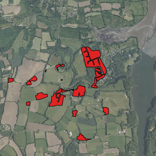
Terrains batis : site de Kerbernez (ORE AgrHyS)
Surfaces occupées par les terrains bâtis. Les sièges d'exploitations les lotissements et les habitations sont représentés sur la couche.
La couche a été créée à partir du plan cadastral disponible sur Géobretagne: http://geobretagne.fr/geoserver/wms
et de l'orthophotographie et du scan 25 de l'IGN
Simple
- Date (Creation)
- 2011-08-08T00:00:00
- Edition
-
2011
- Citation identifier
- fr-18007003900276-umrsas-ore-kbz_bati
- Presentation form
- Digital map
- Purpose
-
AgrHyS est un des 25 Observatoires de Recherche en Environnement (ORE) labellisés par le Ministère de la Recherche en 2002. Il a pour objectif d’étudier les temps de réponse des flux hydrologiques et hydrogéochimiques à l'évolution des agro-hydrosystèmes.
- Status
- Completed
- Point of contact
-
Organisation name Individual name Electronic mail address Role UMR 1069 SAS INRA - Agrocampus Ouest
Contact ORE AgrHyS
Point of contact
- Maintenance and update frequency
- As needed
-
external.place.ore
-
-
Kerbernez
-
-
external.place.thematiques
-
-
Occupation du Sol
-
-
external.place.departements
-
-
Finistère
-
- Keywords
-
-
données ouvertes
-
- Use limitation
-
Usage libre sous réserve des mentions obligatoires sur tout document de diffusion : "Source : UMR 1069 SAS INRA - Agrocampus Ouest"
- Use limitation
-
Licence ouverte : http://wiki.data.gouv.fr/wiki/Licence_Ouverte_/_Open_Li
cence
- Access constraints
- Other restrictions
- Use constraints
- License
- Other constraints
-
Pas de restriction d’accès public
- Spatial representation type
- Vector
- Denominator
- 5000
- Language
-
fre
- Character set
- UTF8
- Topic category
-
- Farming
- Begin date
- 2011-08-08T10:36:00
- End date
- 2016-08-08T10:36:00
))
- Reference system identifier
- EPSG:2154
- Reference system identifier
- EPSG / RGF93 / Lambert-93 (EPSG:2154) / 7.4
- Distribution format
-
Name Version ESRI shapefile
ESRI shapefile
- Distributor contact
-
Organisation name Individual name Electronic mail address Role UMR 1069 SAS INRA - Agrocampus Ouest
GeoSAS
Point of contact
Digital transfer options
- OnLine resource
-
Protocol Linkage Name WWW:LINK-1.0-http--link
http://www.inra.fr/ore_agrhys Site Web de l'observatoire de recherche en environnement AgrHyS
WWW:LINK-1.0-http--link
https://geosas.fr/web/ Portail de l information geographique de l UMRSAS
WWW:LINK-1.0-http--link
https://geosas.fr/portails?portail=vidae Portail cartographique de AgrHyS
WWW:DOWNLOAD-1.0-http--download
https://geosas.fr/geoserver/wfs?service=WFS&version=2.0.0&request=GetFeature&typeName=ore:kbz_bati&outputFormat=SHAPE-ZIP OGC:WMS
https://geosas.fr/geoserver/ore/ows?service=WMS&request=GetCapabilities kbz_bati
- Hierarchy level
- Dataset
- Statement
-
Création couche vecteur (LE GUILLOU. F., 2011)
Metadata
- File identifier
- 69598356-e3af-4e5b-9b66-d936a3faa136 XML
- Metadata language
-
fre
- Character set
- UTF8
- Parent identifier
-
ORE AgrHyS : Site de Kerbernez
29e85205-f44a-420c-ae17-afb1d1b055f4
- Hierarchy level
- Dataset
- Date stamp
- 2016-10-24T12:40:07
- Metadata standard name
-
ISO 19115:2003/19139
- Metadata standard version
-
1.0
- Metadata author
-
Organisation name Individual name Electronic mail address Role UMR 1069 SAS INRA - Agrocampus Ouest
Service GéoSAS
Point of contact
)))