GeoDataINRAE
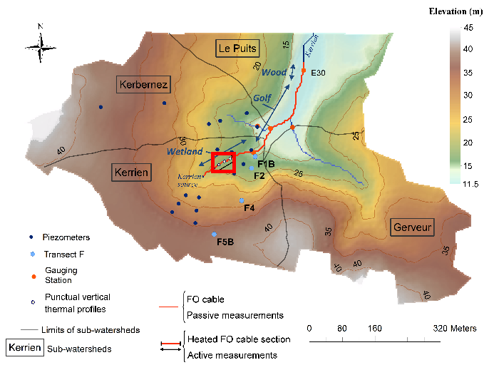
Kerbernez : Active-Distributed Temperature Sensing (DTS) measurements – April 6th,2016
Data corresponding to the active-DTS experiment conducted in Kerrien by deploying and burying an heatable FO cable in the streambed sediments (in the wetland area).
Further details are available in the file: http://agrhys.fr/BVE/nataline/mesuresactives/infos.pdf and results are presented in Simon et al. (2021)
Simple
- Date (Creation)
- 2021-04-06T00:00:00
- Edition
-
2021
- Citation identifier
- fr-18007003900276-umrsas-ore-kbz_adts
- Presentation form
- Digital document
- Purpose
-
Active-DTS measurements conducted in streams are infrequent. Any could use these data to test data interpretation methods for instance.
- Status
- Completed
- Point of contact
-
Organisation name Individual name Electronic mail address Role UMR 1069 SAS INRA - Agrocampus Ouest
Contact ORE AgrHyS
Point of contact Géosciences Rennes, University of Rennes 1
Olivier BOUR
Point of contact
- Maintenance and update frequency
- As needed
-
external.place.ore
-
-
Kerbernez
-
-
external.place.thematiques
-
-
Hydrology
-
-
external.place.departements
-
-
Finistère
-
- Keywords
-
-
open data
-
données ouvertes
-
-
INSPIRE themes
-
-
Hydrographie
-
Installations de suivi environnemental
-
- Use limitation
-
Usage libre sous réserve des mentions obligatoires sur tout document de diffusion : "Source : UMR 1069 SAS INRAE - Institut Agro / UMR 6118 Géosciences Rennes, University of Rennes 1"
- Use limitation
-
Open licence : http://wiki.data.gouv.fr/wiki/Licence_Ouverte_/_Open_Li
cence
- Access constraints
- Other restrictions
- Use constraints
- License
- Other constraints
-
Pas de restriction d’accès public
- Spatial representation type
- Text, table
- Denominator
- 1000
- Language
-
eng
- Character set
- UTF8
- Topic category
-
- Inland waters
- Begin date
- 2016-04-06T08:21:00
- End date
- 2016-04-06T16:29:00
))
- Supplemental Information
-
See Section 2 in pdf file : http://agrhys.fr/BVE/nataline/mesuresactives/infos.pdf
- Reference system identifier
- None
- Distribution format
-
Name Version ZIP
- Distributor contact
-
Organisation name Individual name Electronic mail address Role UMR 1069 SAS INRA - Agrocampus Ouest
Christophe Geneste
Point of contact
Digital transfer options
- OnLine resource
-
Protocol Linkage Name WWW:LINK-1.0-http--link
https://www6.inrae.fr/ore_agrhys Site Web de l'observatoire de recherche en environnement AgrHyS
WWW:DOWNLOAD-1.0-http--download
http://agrhys.fr/BVE/nataline/mesuresactives/datas.zip WWW:DOWNLOAD-1.0-http--download
http://agrhys.fr/BVE/nataline/mesuresactives/infos.pdf
Digital transfer options
- Hierarchy level
- Dataset
- Statement
-
A 150 m length of BruSens FO cable has been connected to a FO-DTS control unit, a Silixa Ultima S instrument. The unit was configured in double-ended configuration to collect data at 12.5 sampling cm and 60 seconds time interval. The effective spatial resolution of DTS measurements with this unit was estimated varying between 66 and 90 cm. Two sections of 20 m of FO cable were installed inside calibration baths (a cold calibration bath and a warm one) and RBR SoloT probes (0.002°C accuracy) were used to calibrate the data.
Metadata
- File identifier
- 535a3738-0ed7-4376-99f1-9a7a652b893d XML
- Metadata language
-
fre
- Character set
- UTF8
- Parent identifier
-
ORE AgrHyS : Site de Kerbernez
29e85205-f44a-420c-ae17-afb1d1b055f4
- Hierarchy level
- Dataset
- Date stamp
- 2021-03-16T09:45:03
- Metadata standard name
-
ISO 19115:2003/19139
- Metadata standard version
-
1.0
- Metadata author
-
Organisation name Individual name Electronic mail address Role UMR 1069 SAS INRA - Agrocampus Ouest
Service GéoSAS
Point of contact
)))