GeoDataINRAE
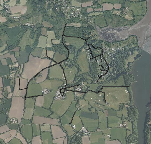
Routes, chemins : site de Kerbernez (ORE AgrHyS)
Représentation des routes et chemins du site d'étude INRA de Kerbernez.
Les routes ont été tracées à partir de l'orthophotographie IGN 2011 et du scan 25 IGN 2011
Simple
- Date (Creation)
- 2011-08-05T00:00:00
- Edition
-
2011
- Citation identifier
- fr-18007003900276-umrsas-ore-kbz_routes
- Presentation form
- Digital map
- Purpose
-
AgrHyS est un des 25 Observatoires de Recherche en Environnement (ORE) labellisés par le Ministère de la Recherche en 2002. Il a pour objectif d’étudier les temps de réponse des flux hydrogéochimiques à l'évolution des agro-hydrosystèmes.
- Status
- Completed
- Point of contact
-
Organisation name Individual name Electronic mail address Role UMR 1069 SAS INRA - Agrocampus Ouest
Contact ORE AgrHyS
Originator
- Maintenance and update frequency
- As needed
-
external.place.departements
-
-
Finistère
-
-
external.place.thematiques
-
-
Occupation du Sol
-
-
external.place.ore
-
-
Kerbernez
-
- Keywords
-
-
données ouvertes
-
-
INSPIRE themes
-
-
Réseaux de transport
-
Installations de suivi environnemental
-
- Access constraints
- Copyright
- Use constraints
- Copyright
- Spatial representation type
- Vector
- Denominator
- 5000
- Language
-
fre
- Character set
- UTF8
- Topic category
-
- Farming
- Begin date
- 2011-08-05T15:44:00
- End date
- 2016-08-05T15:45:00
))
- Supplemental Information
-
Champs de la table d'attributs
Nom: nom de la route
Surface: surface du segment de route
- Reference system identifier
- EPSG:2154
- Reference system identifier
- EPSG / RGF93 / Lambert-93 (EPSG:2154) / 7.4
- Distribution format
-
Name Version ESRI shapefile
ESRI shapefile
- Distributor contact
-
Organisation name Individual name Electronic mail address Role UMR 1069 SAS INRA - Agrocampus Ouest
GéoSAS
Distributor
Digital transfer options
- OnLine resource
-
Protocol Linkage Name WWW:LINK-1.0-http--link
http://www.inra.fr/ore_agrhys Site Web de l'observatoire de recherche en environnement AgrHyS
WWW:LINK-1.0-http--link
https://geosas.fr/web/ Portail de l information geographique de l UMRSAS
WWW:DOWNLOAD-1.0-http--download
https://geosas.fr/geoserver/wfs?service=WFS&version=2.0.0&request=GetFeature&typeName=ore:kbz_routes&outputFormat=SHAPE-ZIP OGC:WMS
https://geosas.fr/geoserver/ore/wms?service=WMS&request=GetCapabilities kbz_routes
- Hierarchy level
- Dataset
- Statement
-
Création couche vecteur (LE GUILLOU. F., 2011)
Metadata
- File identifier
- 523add61-e397-48ed-9eec-ba1510ee66dd XML
- Metadata language
-
fre
- Character set
- UTF8
- Parent identifier
-
ORE AgrHyS : Site de Kerbernez
29e85205-f44a-420c-ae17-afb1d1b055f4
- Hierarchy level
- Dataset
- Date stamp
- 2020-12-15T15:14:50
- Metadata standard name
-
ISO 19115:2003/19139
- Metadata standard version
-
1.0
- Metadata author
-
Organisation name Individual name Electronic mail address Role UMR 1069 SAS INRA - Agrocampus Ouest
Service GéoSAS
Point of contact
)))