GeoDataINRAE
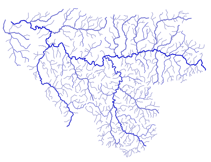
Waterways in the Sélune watershed - Sélune Observatory
The removal of the dams on the Sélune River is the subject of a scientific program launched in 2012, in which environmental parameters are monitored in order to provide real feedback on this restoration operation.
In 2019, a data observatory was set up to collect and process these parameters (biotic and abiotic). The data acquired from 2012 and at least until 2027 will be centralized using an information system (IS) called SISelune. SISelune aims to assist scientists associated with the Sélune program and make the data accessible to all.
Watercourses are linear hydrographic entities, linked to a main place name and broken down into hydrographic sections.
These watercourses are extracted from the Topage database covering the study area. Codes that can be used within the Sélune program have been added, as well as codes from the former hydrographic reference system (Carthage database).
Simple
- Date (Creation)
- 2025-02-12T00:00:00
- Edition
-
2021
- Citation identifier
- fr-18007003900276-umrsas-selune-v_ctxt_cours_eau
- Purpose
-
This layer, created from the TOPAGE and CARTHAGE reference databases, provides a list of watercourses in the Sélune watershed.
- Status
- Completed
- Point of contact
-
Organisation name Individual name Electronic mail address Role UMR ESE INRAE - Agrocampus Ouest
Jean-Marc Roussel
Point of contact AESN
funder
- Maintenance and update frequency
- As needed
- Keywords
-
-
Données ouvertes
-
Hydrologie
-
- Keywords
-
-
Limite
-
-
INSPIRE themes
-
-
Hydrographie
-
- Use limitation
-
Usage libre sous réserve des mentions obligatoires sur tout document de diffusion : "Source : UMR DECOD INRAE - Agrocampus Ouest"
- Use limitation
-
Licence ouverte : https://www.etalab.gouv.fr/licence-ouverte-open-licence
- Access constraints
- Other restrictions
- Use constraints
- License
- Other constraints
-
Pas de restriction d’accès public
- Spatial representation type
- Vector
- Denominator
- 25000
- Language
-
fre
- Topic category
-
- Inland waters
- Environment
- Description
-
Secteur hydrographique "I9" (correspondant à la Sélune de sa source à l'embouchure
))
- Reference system identifier
- RGF93 / Lambert-93 (EPSG:2154)
- Geometric object type
- Point
Distributor
- Distributor contact
-
Organisation name Individual name Electronic mail address Role UMR 1069 SAS INRA - Agrocampus Ouest
Pole GéoSAS
Distributor
- Distributor format
-
Name Version ESRI Shapefile
1.0
Digital transfer options
- OnLine resource
-
Protocol Linkage Name OGC:WMS
https://geosas.fr/geoserver/wms?SERVICE=WMS&REQUEST=GetCapabilities selune:v_ctxt_hydro_cours_eau
WWW:DOWNLOAD-1.0-http--download
https://geosas.fr/geoserver/selune/ows?service=WFS&version=1.0.0&request=GetFeature&typeName=selune%3Av_ctxt_hydro_cours_eau&outputFormat=SHAPE-ZIP WWW:LINK-1.0-http--link
https://programme-selune.com/fr/observatoire/ Observatoire Sélune
WWW:DOWNLOAD-1.0-http--download
https://geosas.fr/geoserver/selune/ows?service=WFS&version=1.0.0&request=GetFeature&typeName=selune%3Av_ctxt_hydro_cours_eau&outputFormat=CSV
- Hierarchy level
- Dataset
Conformance result
- Title
-
INSPIRE Data Specification for the spatial data theme Elevation
- Date (Publication)
- 2013-12-10
- Explanation
-
Non Evalué
- Pass
- No
- Statement
-
These watercourses are extracted from the Topage database covering the study area. Codes that can be used within the Sélune program have been added, as well as codes from the former hydrographic reference system (Carthage database).
- Feature catalogue citation
Metadata
- File identifier
- 1c7945a5-0e93-4807-b839-0a070d9af639 XML
- Metadata language
-
fre
- Character set
- UTF8
- Parent identifier
-
Programme scientifique Sélune
32b2d23e-0f67-46fb-ad72-110514f1c8ee
- Hierarchy level
- Dataset
- Date stamp
- 2025-10-28T09:28:50
- Metadata standard name
-
ISO 19115
- Metadata standard version
-
1.0
- Metadata author
-
Organisation name Individual name Electronic mail address Role UMR 1069 SAS INRA - Agrocampus Ouest
GéoSAS
Point of contact
- Other language
-
Language Character encoding English French UTF8
)))