GeoDataINRAE
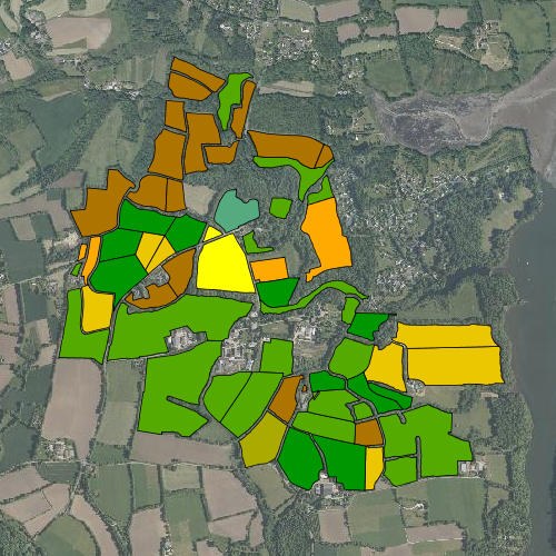
Assolements de 1992 à 2011 : site de Kerbernez (ORE AgrHyS)
Carte des assolements du site d'étude INRA de Kerbernez.
Les assolements sont renseignés de 1992 à 2011. Une ou plusieurs cultures peuvent être renseignées au cours d'une année (culture de printemps et culture d'hiver)
La couche vecteur a été crée à partir des données de Laurent RUIZ et de la carte parcellaire issue du travail de Samuel ABIVEN (ABIVEN. S., 2000)
Simple
- Date (Revision)
- 2015-12-04T00:00:00
- Edition
-
2015
- Citation identifier
- fr-18007003900276-umrsas-ore-kbz_assolement
- Presentation form
- Digital map
- Purpose
-
AgrHyS est un des 25 Observatoires de Recherche en Environnement (ORE) labellisés par le Ministère de la Recherche en 2002. Il a pour objectif d’étudier les temps de réponse des flux hydrogéochimiques à l'évolution des agro-hydrosystèmes.
- Status
- Completed
- Point of contact
-
Organisation name Individual name Electronic mail address Role UMR 1069 SAS INRA - Agrocampus Ouest
Contact ORE AgrHyS
Point of contact
- Maintenance and update frequency
- As needed
-
external.place.thematiques
-
-
Occupation du Sol
-
-
external.place.departements
-
-
Finistère
-
- Keywords
-
-
données ouvertes
-
-
INSPIRE themes
-
-
Occupation des terres
-
-
UMR SAS Themes
-
-
Occupation du Sol
-
- Use limitation
-
Usage libre sous réserve des mentions obligatoires sur tout document de diffusion : "Source : UMR 1069 SAS INRA - Agrocampus Ouest"
- Use limitation
-
Licence ouverte : http://wiki.data.gouv.fr/wiki/Licence_Ouverte_/_Open_Li
cence
- Access constraints
- Other restrictions
- Use constraints
- License
- Other constraints
-
Pas de restriction d’accès public
- Spatial representation type
- Vector
- Denominator
- 5000
- Language
-
fre
- Character set
- UTF8
- Topic category
-
- Farming
- Begin date
- 2011-08-05T14:32:00
- End date
- 2016-08-05T14:32:00
))
- Reference system identifier
- WGS 1984
- Reference system identifier
- EPSG / RGF93 / Lambert-93 (EPSG:2154) / 7.4
- Distribution format
-
Name Version ESRI shapefile
ESRI shapefile
- Distributor contact
-
Organisation name Individual name Electronic mail address Role UMR 1069 SAS INRA - Agrocampus Ouest
GeoSAS
Distributor
Digital transfer options
- OnLine resource
-
Protocol Linkage Name WWW:LINK-1.0-http--link
http://www.inra.fr/ore_agrhys Site Web de l'observatoire de recherche en environnement AgrHyS
WWW:LINK-1.0-http--link
https://geosas.fr/web/ Portail de l information geographique de l UMRSAS
OGC:WMS
https://geosas.fr/geoserver/ore/ows?service=WMS&request=GetCapabilities kbz_assolement
WWW:DOWNLOAD-1.0-http--download
https://geosas.fr/geoserver/wfs?service=WFS&version=2.0.0&request=GetFeature&typeName=ore:kbz_assolement&outputFormat=SHAPE-ZIP
Digital transfer options
Digital transfer options
- Hierarchy level
- Dataset
- Statement
-
Création couche vecteur (LE GUILLOU. F., 2011)
Metadata
- File identifier
- 1216db12-7dd2-4c57-ade7-beea76ae5f61 XML
- Metadata language
-
fre
- Character set
- UTF8
- Parent identifier
-
ORE AgrHyS : Site de Kerbernez
29e85205-f44a-420c-ae17-afb1d1b055f4
- Hierarchy level
- Dataset
- Date stamp
- 2016-10-24T12:42:46
- Metadata standard name
-
ISO 19115:2003/19139
- Metadata standard version
-
1.0
- Metadata author
-
Organisation name Individual name Electronic mail address Role UMR 1069 SAS INRA - Agrocampus Ouest
Service GéoSAS
Point of contact
)))