GeoDataINRAE
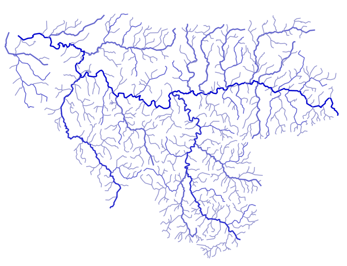
Hydrographic sections of the Sélune watershed - Sélune Observatory
The hydrographic sections, which make up the waterways, were extracted from the Topage database covering the study area.
Simple
- Date (Creation)
- 2025-02-12T00:00:00
- Edition
-
2021
- Citation identifier
- fr-18007003900276-umrsas-selune-v_ctxt_cours_eau
- Purpose
-
This layer, created from the TOPAGE reference database, provides a list of hydrographic sections in the Sélune watershed.
- Status
- Completed
- Point of contact
-
Organisation name Individual name Electronic mail address Role UMR ESE INRAE - Agrocampus Ouest
Jean-Marc Roussel
Point of contact AESN
funder
- Maintenance and update frequency
- As needed
- Keywords
-
-
Données ouvertes
-
Hydrologie
-
- Keywords
-
-
Limite
-
-
INSPIRE themes
-
-
Hydrographie
-
- Use limitation
-
Usage libre sous réserve des mentions obligatoires sur tout document de diffusion : "Source : UMR DECOD INRAE - Agrocampus Ouest"
- Use limitation
-
Licence ouverte : https://www.etalab.gouv.fr/licence-ouverte-open-licence
- Access constraints
- Other restrictions
- Use constraints
- License
- Other constraints
-
Pas de restriction d’accès public
- Spatial representation type
- Vector
- Denominator
- 25000
- Language
-
fre
- Topic category
-
- Inland waters
- Environment
- Description
-
Secteur hydrographique "I9" (correspondant à la Sélune de sa source à l'embouchure
))
- Reference system identifier
- RGF93 / Lambert-93 (EPSG:2154)
- Geometric object type
- Point
Distributor
- Distributor contact
-
Organisation name Individual name Electronic mail address Role UMR 1069 SAS INRA - Agrocampus Ouest
Pole GéoSAS
Distributor
- Distributor format
-
Name Version ESRI Shapefile
1.0
Digital transfer options
- OnLine resource
-
Protocol Linkage Name OGC:WMS
https://geosas.fr/geoserver/wms?SERVICE=WMS&REQUEST=GetCapabilities selune:v_ctxt_hydro_troncon
WWW:DOWNLOAD-1.0-http--download
https://geosas.fr/geoserver/selune/ows?service=WFS&version=1.0.0&request=GetFeature&typeName=selune%3Av_ctxt_hydro_cours_eau&outputFormat=SHAPE-ZIP WWW:LINK-1.0-http--link
https://programme-selune.com/fr/observatoire/ Observatoire Sélune
WWW:DOWNLOAD-1.0-http--download
https://geosas.fr/geoserver/selune/ows?service=WFS&version=1.0.0&request=GetFeature&typeName=selune%3Av_ctxt_hydro_cours_eau&outputFormat=CSV
- Hierarchy level
- Dataset
Conformance result
- Title
-
INSPIRE Data Specification for the spatial data theme Elevation
- Date (Publication)
- 2013-12-10
- Explanation
-
Non Evalué
- Pass
- No
- Statement
-
The hydrographic sections, which make up the waterways, were extracted from the Topage database covering the study area.
- Feature catalogue citation
Metadata
- File identifier
- 0db80ac4-272b-4606-9a82-afaff3d0f574 XML
- Metadata language
-
fre
- Character set
- UTF8
- Parent identifier
-
Programme scientifique Sélune
32b2d23e-0f67-46fb-ad72-110514f1c8ee
- Hierarchy level
- Dataset
- Date stamp
- 2025-10-09T17:06:40
- Metadata standard name
-
ISO 19115
- Metadata standard version
-
1.0
- Metadata author
-
Organisation name Individual name Electronic mail address Role UMR 1069 SAS INRA - Agrocampus Ouest
GéoSAS
Point of contact
- Other language
-
Language Character encoding English French UTF8
)))